Early Stephens County ranches/forts
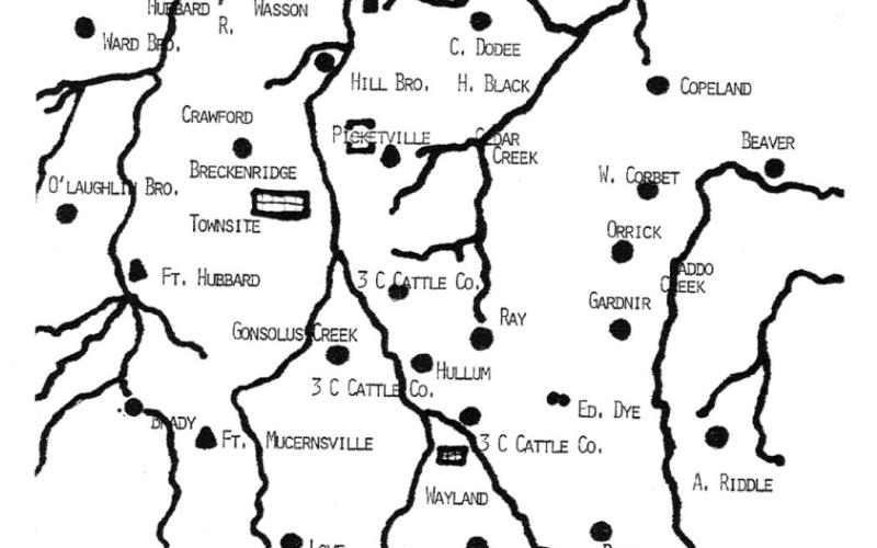
I ran across this early diagram of Stephens County made in about 1876, with the locations of the forts I have been writing about the last few weeks. Fort Davis is up in the far left-hand corner along the Brazos River. The ranches located near there include the Ward Brothers, Adkin Brothers (Atkin?) and the Wasson Cattle Ranch.
As we move further south and slightly to the East, there is the location of Fort Cooper, which was established in 1856, and just south of it are the ranches of the Hill Brothers, the Henry Black Ranch and C. Dodee. The small village of Crystal Falls is not shown, nor is the Robertson Ranch, which was established prior to Henry Black coming to Stephens County in 1875.
As one moves further south, there is the village of Picketville which was established as early as the mid-1850s and was a thriving small town. Originally, there were 56 graves in the Picketville Cemetery, but an errant bulldozer pushed several off into the creek below before someone could stop him. One of the few surviving tombstones is that of Phoebe Boggs. On the far left of the map, is the proposed location of the Breckenridge townsite and south of it to the west is Fort Hubbard.
If you move further South to the West, Fort Murcernville is noted, which I am not familiar with and am wondering if they meant Fort Muggainsville, because that is about where it would have been located.
East of the 3 C Cattle Company, the Ed Dye Sheep Ranch is shown, which would not have been very popular in cattle country. Peter and Christina Swenson also began with sheep when they arrived in this county South of Caddo, in 1879. It is not shown, but he and Christina brought their young daughter and son along with his brother Nils and eventually established a community of Swensondale near their ranch and farmland. The Swenson’s brought a mixture of their Norwegian and Swedish backgrounds and started with 100 acres, which grew to more than 8,500 acres and many cattle and horses long after this diagram had already been constructed. Peter built a three-story mansion for Christina, South of Caddo about two miles, that is still standing, but needs a fresh coat of paint to go with the new roof. It is a Stephens County landmark built, in 1910-12. The townsite of Wayland also is shown.
Notice the other names of early ranches in Stephens County. Up in the far northeastern part of the county is Benjamin E. Burgess, who purchased about 5,000 acres near the Brazos River.
Also, note the W. Corbet Ranch, established in 1877 by Aaron Wilson and Lizzie (McFarland) Corbett. He was buried in the Bee Branch Cemetery with his first wife, Mollie Mary (Coapland) Corbett on his right and second wife, Mary Elizabeth ‘Lizzie’ (McFarland) Corbett buried on his left.
Additionally, Camp Salmon is not shown in the extreme southwestern corner of the county. It was named for Capt. Salmon, who commanded Camp Breckenridge, which was established in 1862, which was much later than this diagram was produced.
Many of these people I have written about previously, but there are a few names I have failed to mention and they include A. Riddle, Gardiner, C. Dodee, E. L. Love, Beaver and Orrick. I will do some more research and see if I can remedy that in the coming weeks.
I just thought it might be useful to see what was in existence in this county about the time the townsite of Breckenridge was established officially as the County Seat.
Also, if you have not seen a copy of the Historic Map of Stephens County, the Swenson Memorial Museum has them for sale for $5. I’m not trying to drum up business for them, but that Stephens County Historical map is very useful because it shows the old wagon roads established in the 1850s and our historic Half-Way Oak. That historic map was developed back as early as 1858 and well worth having if you are tracking Stephens County history.
- Log in to post comments


